Mt. Rose Scenic Drive
The Mt. Rose Scenic Drive is a paved, twenty-five mile long scenic drive between Reno and Lake Tahoe. Travelers on the route will have excellent views of Washoe Valley, Washoe Lake, the Lake Tahoe Basin and the high peaks of the Sierras.
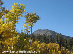
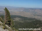
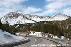
The Mt. Rose Scenic Drive follows Nevada State Highway 431 (also simply known as the Mt. Rose Highway) for its entire length. Beginning in Reno at the junction with Highway 395 at an elevation of 4500 feet, the drive climbs steadily through high-desert terrain that has seen significant development over the past decade, until reaching the edge of the Sierras. There are no foothills here. Instead, the mountains rise steeply and sharply up from the valley below. Additionally, once the Mt. Rose Highway reaches the mountains, the vegetation changes remarkably fast, with the desert quickly giving way to rocky and forested mountain slopes.
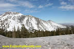
Once the Mt. Rose Highway reaches the mountains, the route climbs steadily, with numerous twists and turns, as it makes its way up to the highest elevation point of the drive, the 8900 foot Mt. Rose Summit. Now, don’t let the name fool you. Mt. Rose Summit isn’t a mountain summit at all, but is instead a pass located between the 10,776 foot Mt. Rose (located to the north of the road) and the 9,648 foot Slide Peak (located to the south of the road).
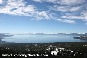
From Mt. Rose Summit, the Mt. Rose Highway then passes through forested terrain while dropping steadily into the Lake Tahoe Basin. The views on this stretch of the road are outstanding, and several scenic pullovers are located just outside of Incline Village that provide unrestricted and sweeping views of Lake Tahoe, the high peaks of the Sierras in California, and the entire Tahoe Basin. The scenic drive ends at the junction with Nevada State Highway 228, which is part of the Lake Tahoe Scenic Drive, near Incline Village.
The traffic on the Mt. Rose Scenic Drive ranges from moderate to heavy, depending on the weather and time of year. Since the highway is one of the main routes between Reno and the Lake Tahoe Basin, the drive is often very busy during the summer, especially on weekends. Additionally, as the Mt. Rose Ski Area is located along the route, during the winter the road can also have significant ski-related traffic.
Despite the high elevation of the drive, the Mt. Rose Scenic Drive is open year-round. The Mt. Rose Summit (the pass on the road at 8900 feet) is the highest elevation Sierra pass that is open year-round – not an easy feat since Mt. Rose Summit receives up to 400 inches of snow during the winter! However, anyone taking this route in the winter should be aware that during and immediately after winter storms, the road likely will be closed to allow for snow removal operations and, just as importantly, avalanche control. Snow tires and/or snow chains are also frequently required for winter travel, too.
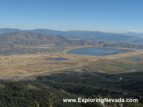
Anyone taking this drive should take a short, two-mile detour that leads to the Winters Creek Base Lodge at Mt. Rose Ski Area. This road provides excellent views of Washoe Lake and the Washoe Valley 4000 vertical feet below. When looking for this road, just follow the sign that points the way to “Mt. Rose Slide Bowl.”
There are several campgrounds located along the route, although they fill up quickly and early during the summer months. Due to the steep nature of the drive and the lack of side roads, however, there are only a handful of spots where a person can pull over and primitive camp. For primitive camping, it is best to either stay in the Tahoe Basin or cut across the Washoe Valley and take the Virginia City Scenic Drive, which passes through large holdings of BLM land.
Overall, the Mt. Rose Scenic Drive is a beautiful drive that is simple to reach and provides outstanding views. Anyone who happens to be in the Tahoe Basin, or who is simply passing through Reno on Interstate 80, should take the time to drive this very scenic route.
Quick Facts About the Mt. Rose Scenic Drive
- Trip Length : 25 miles, one-way. The route follows NV Highway 431 between Reno and Incline Village.
- Road Type - The road is paved for its entire distance and in good condition.
- RV's / Campers? - Yes, but parts of the road are steep and twisty.
- Services Available - Gas and supplies can be found in Reno and Incline Village. There are no services along the route itself once the drive leaves Reno.
- General Location - Western Nevada, just outside of Reno and to the east of Lake Tahoe.
- Camping - There is no camping spots along the route itself. However, there is many developed campgrounds in the Lake Tahoe Basin, including at Lake Tahoe Nevada State Park, right outside of Incline Village.
Map of the Mt. Rose & Nearby Scenic Drives

|
Suggested Books
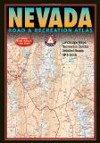 |
Benchmark Nevada Road & Recreation Atlas : This topographic map book shows ALL roads in Nevada. This book is a mandatory requirement if you'll be venturing off the main highways shown on the tourist map. Additionally, this book shows many historical sites, points of interest and recreation areas.
More Info at Amazon
|
|
Related Articles & Information on Exploring Nevada
|
Copyright © 2007 - 2026 Exploring Nevada.Com
|
|
|