Caliente, Nevada : Information & Photographs
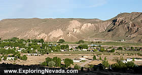
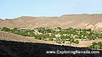
Caliente is a nice town located in eastern Nevada, on US Highway 93. Since Caliente is located on US 93, the town serves as a welcome rest stop for travelers since there is little between Caliente and Interstate 15/Las Vegas.
Yet Caliente is more than just a handy rest stop on the way between Las Vegas and Ely. Caliente has a great location for outdoor interests. Beaver Dam State Park, Kershaw-Ryan State Park and Cathedral Gorge State Park are all located nearby. The enjoyable Rainbow Canyon Scenic Drive begins just south of town. And several large wilderness areas managed by the Bureau of Land Management, such as the Clover Mountains Wilderness Area, are located nearby.
Caliente is also a popular place to visit to escape the heat of southern Nevada. Caliente has an elevation of 4300 feet, keeping summer weather cooler than the temperatures found further south in Mesquite or Las Vegas.
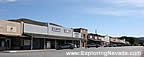
The downtown of Caliente, which is located on the opposite side of the railroad tracks from US Highway 93, is small but clean. Although Caliente has no big box stores, the town still has all the basics one needs.
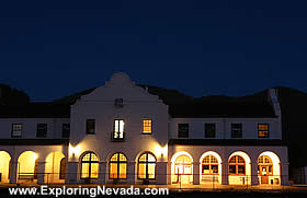
Anyone passing through Caliente can’t help but notice the beautiful train depot. Built by the Union Pacific in 1905, the depot was built in the style of Spanish Mission architecture. For many years, the train depot served as an Amtrak stop. However, when Amtrak stopped running the route between Los Angeles/Las Vegas/Salt Lake City, the depot was donated to the City of Caliente and then restored. The depot now serves as a museum and holds a few other offices, too.
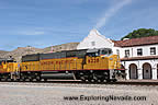
Speaking of trains, the mainline of the Union Pacific Railroad passes right through Caliente. This section of the Union Pacific is very busy, with packs of trains running together with often no more than ten to twenty minutes of separation between them. Additionally, the Union Pacific passes through several tunnels in Rainbow Canyon. For the rail fan photographer, Caliente and Rainbow Canyon is a great place to visit.
Overall, Caliente makes for a handy rest stop for travelers as well as providing a great base area for those heading out into the Nevada backcountry beyond Caliente. For those with time to spare when visiting Caliente, consider driving down the Rainbow Canyon Scenic Drive and taking the twenty mile gravel road out toward Beaver Dam State Park.
Suggested Books
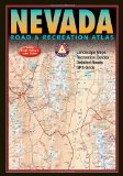 |
Benchmark Nevada Road & Recreation Atlas : This topographic map book shows ALL roads in Nevada. This book is a mandatory requirement if you'll be venturing off the main highways shown on the tourist map. Additionally, this book shows many historical sites, points of interest and recreation areas.
More Info at Amazon
|
|
Where to Stay in Caliente
There are no hotels available for online booking in Caliente. However, there are a few locally owned motels in town. Developed campgrounds can be found in the Kershaw-Ryan State Park just south of town as well as at Beaver Dam State Park that is twenty-eight miles to the east of town. Primitve camping is also available anywhere on the BLM lands that surround town. |
Related Articles & Information on Exploring Nevada
|
Copyright © 2007 - 2026 Exploring Nevada.Com
|
|
|