The Spring Valley Scenic Drive
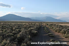
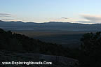
Beginning in the shadow of Wheeler Peak and the high peaks of Great Basin National Park, the Spring Valley Scenic Drive is a fabulous drive in east-central Nevada, near Ely. The Spring Valley Scenic Drive takes the traveler through the sprawling and empty Spring Valley, with some of the tallest mountains in Nevada flanking the valley to the east and west. Those who enjoy towering mountains that rise steeply and abruptly off an empty and remote valley floor will definitely enjoy this drive.
The Spring Valley Scenic Drive follows Nevada State Highway 893 for its entire length, running between US Highway 93 to the north (at the Schellbourne Rest Area) and US Highway 50 to the south. For the southern half of the drive, the road is paved. The road then switches over to gravel for the northern half of the route. The gravel portion of the drive is in good condition. The road shouldn’t pose any problems to travelers except during periods of inclement weather.
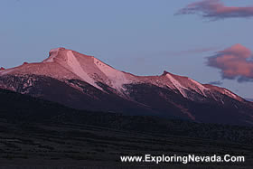
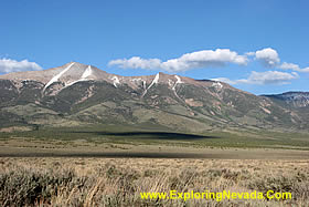
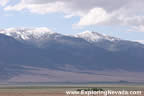
The views on this route are truly outstanding. Rising abruptly more than 6000 vertical feet off the valley floor, the Snake Range, including 13,000 foot Wheeler Peak, loom to the east of the valley and provide a dramatic contrast to the sprawling valley. The views to the west of Spring Valley are equally wonderful, as the tall and snow-covered peaks of the Schell Creek Range dominate the horizon.
When starting from the south, this scenic drive begins at the junction of Nevada State Highway 893 and US Highway 50 twenty-eight miles to the east of Ely. The junction is not especially well marked, and it is quite easy to zoom right by Highway 893 if not paying attention (which is easy to do, as the views of Wheeler Peak are outstanding). When looking for the road, look for the sign that points the way to Cleve Creek Recreation Area, a BLM recreation area located about 15 miles north of US Highway 50.
The Spring Valley Scenic Drive, despite its length of 68 miles, doesn’t pass through a single town. Indeed, there is scarcely any development at all along the route. Moreover, Highway 893 doesn’t really “go anywhere.” Instead, as the map below shows, the highway simply is a scenic route that passes to the east of the Schell Creek Range before turning to the west and linking up with US Highway 93 to the north of McGill, Nevada. Because of this, traffic on this scenic drive is non-existent, especially on the northern half of the drive. Travelers should come prepared with all supplies needed, since there is nowhere on the drive to obtain them. Also, don’t expect your cell-phone to work, either.
For those who are wondering how to fit this scenic drive into their travel plans, consider taking this route as a “scenic detour” the bypasses Ely when driving on US Highway 93 between Wells (to the north) and Pioche/Interstate 15 (to the south). Just keep in mind that by taking this scenic detour and bypassing Ely, the places to buy gasoline and other supplies is very limited. The distance between Wells and Pioche, when taking the Spring Valley Scenic Drive, is 240 miles. The only place to buy gasoline along this entire stretch is at a small gas station at the junction of US Highway 50 and US Highway 93 at Major’s Place – which is near the southern beginning point of the scenic drive. However, the hours of this gas station are limited and I’m not sure the pumps are available twenty-four hours a day, seven days a week. Therefore, the moral of the story is, make sure you have a full tank of gasoline before driving down this very scenic detour.
Although there is no lodging along this scenic drive (or anywhere near it for that matter), there is plenty of places to camp. The Cleve Creek Recreation Area, operated by the BLM, is just off the scenic drive about fifteen miles north of US Highway 50. Since the drive passes through BLM lands for most of its length, primitive camping is also available everywhere, too.
Overall, the Spring Valley Scenic Drive is an ideal route for anyone who seeks solitude and wants to explore a beautiful part of Nevada that few people ever see.
Quick Facts About the Spring Valley Scenic Drive
- Trip Length : 68 miles, one-way. The route follows Nevada State Highway 893 for its entire length.
- Road Type - The road is paved on the southern half of the drive, then switches over to gravel for the northern half of the drive. The gravel portioin of the road is in good condition.
- RV's / Campers? - Yes.
- Services Available - Gas and supplies can be found in Ely, Baker and McGill.
- General Location - Eastern Nevada, just north of US Highway 50 to the west of Great Basin National Park.
- Camping - The Cleave Creek Campground is located along the scenic drive, and offers developed camping. The drive also passes through public lands for most its length, allowing primtive camping virtually anywhere. Hotels can be found in Ely.
Map of the Spring Valley & Nearby Scenic Drives

|
Suggested Books
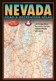 |
Benchmark Nevada Road & Recreation Atlas : This topographic map book shows ALL roads in Nevada. This book is a mandatory requirement if you'll be venturing off the main highways shown on the tourist map. Additionally, this book shows many historical sites, points of interest and recreation areas.
More Info at Amazon
|
|
Copyright © 2007 - 2026 Exploring Nevada.Com
|
|
|