The Spring Mountains Scenic Drive
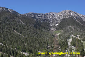
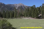
The Spring Mountains Scenic Drive, also known as the Mt. Charleston Loop, is a paved forty-one mile drive that leads up into the high elevations of the Spring Mountains that are located to the northwest of Las Vegas. The drive has significant elevation changes. Starting in the low desert floor just outside of Las Vegas at an elevation of about 3000 feet, the drive climbs high into the mountains and reaches a maximum elevation of nearly 8500 feet. Due to the big changes in elevation, the drive passes through several different life zones, including low desert, juniper forests and finally pine forests.
The Spring Mountains are one of several “outdoor playgrounds” for Las Vegas residents. During the summer, the many high elevation campgrounds located in the Spring Mountains provide a much-needed escape from the heat of the desert. Numerous hiking trails, including the Mt. Charleston National Recreation Trail, lead into the Mt. Charleston Wilderness Area. Further, the Spring Mountains receive just enough snow during the winter months to allow for skiing at the small Las Vegas Ski & Snowboard Resort.
The Spring Mountains Scenic Drive begins and ends off US Highway 95, to the northwest of Las Vegas. Although the drive has a one-way length of 41 miles, most people make a loop of the drive, making the drive a total of 55 miles in length.
The drive follows three paved Nevada State Highways for its entire length; Highway 156, Highway 157 and Highway 158 (see map below).
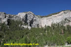
From the southern start point of the drive on Nevada Highway 157, the scenic drive heads east and begins a steady ascent into the mountains. The drive follows Highway 157 for 17 miles before it reaches the junction with Nevada Highway 158. At this junction, the traveler can continue on Highway 157 for a few more miles before the road ends at the parking areas of the trails that lead into the Mt. Charleston Wilderness Area.
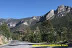
To continue the scenic drive, the traveler will turn north on Nevada Highway 158. This highway continues to gain elevation and offers a number of excellent views of the valley far below. The highway soon crosses a pass at 8400 feet, the highest point of the drive. A few miles below the pass, Nevada Highway 158 ends at the junction with Nevada Highway 156.
At this junction, the scenic drive turns to the east and starts losing elevation as it heads toward US Highway 95. Several developed campgrounds exist off this section of the drive, and more trails head off into the mountains. There are also many trails for horses and ATV’s off this section of the drive.
Overall, the Spring Mountains Scenic Drive is a great diversion just a short hop outside of Las Vegas. Anyone visiting Las Vegas, and who has use of a car, should make time in their schedule to take this very scenic and beautiful drive. And during the summer, the dramatic change in elevation (from 3000 feet to 8400 feet), provides a welcome relief from the high heat found in the lower elevations.
Quick Facts About the Spring Mountains Scenic Drive
- Trip Length : 41 miles, one-way (55 mile loop). The route follows Nevada State Highways 156, 157 & 158.
- Road Type - The road is paved and in good condition for its entire length. Travelers should be prepared for significant elevation changes.
- RV's / Campers? - Yes.
- Services Available - Gas and supplies can be found in Las Vegas and all of the suburbs that sprawl across the valley.
- General Location - Southern Nevada, seventeen miles to the northwest of Las Vegas.
- Camping - The drive passes through public lands for most of its length, so primitive camping is available most everywhere a person can pull over. Many developed campgrounds also exist along the route. Just remember that the campgrounds located at the highest elevations will be chilly at night, even during summer.
Map of the Spring Mountains & Nearby Scenic Drives

|
Suggested Books
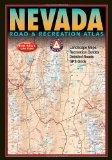 |
Benchmark Nevada Road & Recreation Atlas : This topographic map book shows ALL roads in Nevada. This book is a mandatory requirement if you'll be venturing off the main highways shown on the tourist map. Additionally, this book shows many historical sites, points of interest and recreation areas.
More Info at Amazon
|
|
Related Articles & Information on Exploring Nevada
|
Copyright © 2007 - 2026 Exploring Nevada.Com
|
|
|