Rainbow Canyon Scenic Drive
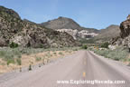
The Rainbow Canyon Scenic Drive is a relaxing and enjoyable ride on a paved road through Rainbow Canyon, a deep canyon located just south of the town of Caliente on State Highway 317. Anyone passing through the town of Caliente of US Highway 93 should make a point of taking this 21-mile (42 miles round-trip) scenic drive.
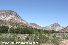
Rainbow Canyon lies between the Delamar Mountains to the west and the Clover Mountains to the east. The canyon is quite deep and steep, with the canyon lying three thousand feet below the higher peaks of the mountains.
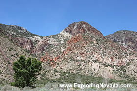
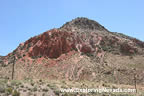
Yet what makes Rainbow Canyon an enjoyable drive isn’t tall mountains, but instead the colored rock and interesting rock formations along the road. Throughout the drive, the traveler will see large formations of red rock and rock formations that defy easy description. Additionally, and in contrast to the surrounding mountains, the traveler will come across many cottonwood trees. The reason for all the cottonwood trees is because the drive follows a wash, called the Meadow Valley Wash, for its entire length. This wash usually has no more than a trickle of water in it, but collects enough water during heavy rain events to allow cottonwood trees to grow along its banks.
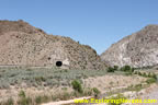
The Rainbow Canyon Scenic Drive closely follows the main line of the United Pacific Railroad for its entire length. This stretch of the Union Pacific is extremely busy, sometimes averaging one train every twenty minutes or so. There are also numerous railroad tunnels and deep cuts along the railroad, providing the rail fan with excellent train watching and photography.
The Rainbow Canyon Scenic Drive follows Nevada State Highway 317 for its entire length, to the ghost town of Elgin. At Elgin, the road splits and becomes gravel. The road that heads to the west is called Kane Springs Road and is usually in very good condition. The drive down Kane Springs Road is quite enjoyable, at least if the traveler enjoys driving through completely empty and isolated countryside. The road passes through the uninhabited and sprawling Kane Springs Valley that lies between the Delamar Mountains and Meadow Valley Mountains. Kane Springs Road links up with US Highway 93 thirty-two miles south of the town of Alamo. As such, the traveler wishing to avoid the rather boring and sometimes busy drive on US Highway 93 between Las Vegas and Caliente can use the Kane Springs Road to reach the Rainbow Canyon Scenic Drive (and follow it north to Caliente, linking back up with US Highway 93) and have a more enjoyable ride, too.
Traffic on the Rainbow Canyon Scenic Drive is exceedingly light. What little traffic is found on the road are usually local ranchers and those who might be heading out into the Clover Mountains Wilderness Area. The traveler should be aware that during periods of heavy rain, the road might pose problems for low-clearance vehicles where the road crosses various washes (riverbeds that are usually dry or just a trickle of water but fill up with gushing water during periods of heavy rain). At these river crossings, the road dips down and crosses the wash with a cement roadbed. However, if the water is deep due to heavy rain, it is possible for a low-clearance vehicle to stall out at one of these crossings. Fortunately, this part of Nevada doesn’t have many heavy rain events during the year (if any). As such, travelers will only need to remember this bit of advice if thunderclouds are building and it’s starting to rain heavily.
Quick Facts About the Rainbow Canyon Scenic Drive
- Trip Length : 21 miles, one-way. Starts in the town of Caliente and ends in the ghost town of Elgin. From Elgin, the traveler can either return to Caliente, follow the Kane Springs Road back to a junction with US Highway 93 south of Alamo, or continue to follow the road south (which turns to gravel and becomes County Road 4230) to Carp and beyond.
- Road Type - The road is paved for its entire length.
- RV's / Campers? - Yes.
- Services Available - Gas and supplies can be found in Caliente. There is no place to buy supplies or gas on the scenic drive.
- General Location - South of Caliente in eastern Nevada.
- Camping - The drive passes through a mix of BLM public lands and private lands. Primitive camping is available on all BLM lands. Additionally, developed camping is available at Kershaw-Ryan State Park, located two miles south of Caliente right off the scenic drive.
Map of the Rainbow Canyon & Nearby Scenic Drives
 |
Suggested Books
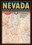 |
Benchmark Nevada Road & Recreation Atlas : This topographic map book shows ALL roads in Nevada. This book is a mandatory requirement if you'll be venturing off the main highways shown on the tourist map. Additionally, this book shows many historical sites, points of interest and recreation areas.
More Info at Amazon
|
|
Where to Stay When Driving the Rainbow Canyon Scenic Drive
Bring your tent or camper, as there is no lodging or services of any kind on this scenic drive although there is lodging in the town of Caliente. Since the scenic drive passes through extensive areas of BLM lands, primitive camping is available. Additionally, there is developed camping at Kershaw-Ryan State Park just south of Caliente. |
Related Articles & Information on Exploring Nevada
|
Copyright © 2007 - 2026 Exploring Nevada.Com
|
|
|