The Desatoya Mountains Scenic Drive
Do you plan to drive down US Highway 50 in Nevada, also known as the “Loneliest Highway in America?” If so, may I suggest a detour for you? A rarely traveled road that leads through the seldom-visited Desatoya Mountains in Nevada and across the sprawling Smith Creek Valley awaits the adventurous traveler. Best of all, in terms of mileage, this scenic drive, which I call the Desatoya Mountains Scenic Drive, is actually shorter than if you stayed on US Highway 50.
The Desatoya Mountains Scenic Drive follows Nevada State Highway 722. The drive is 63 miles in length and paved the entire distance. The road is in good condition for the most part, and except for where the road twists and turns as it crosses a pass through the Desatoya Mountains called Carroll Summit, the road is generally straight and flat.
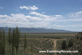
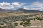
So why would someone want to take this scenic drive? Simple, the road is much more scenic than slogging down US Highway 50. A traveler who takes this drive will have great views of the Desatoya Mountains, a huge sprawling valley called Smith Creek Valley, the towering snow-capped peaks of the Shoshone Mountains, as well as the jagged mountains of the Toiyabe Range. Plus, the traveler will be able to brag to their friends about how they visited a remote part of Nevada that few Nevada residents even know about, let alone visit.
The traveler can begin this drive at either the western side of the Desatoya Mountains at the Highway 722 junction with US Highway 50, or right outside of Austin at the Highway 722/US 50 junction. Either way, the views are outstanding, the remoteness complete and the traffic is non-existent.
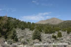
Beginning on the western side of the Desatoya Mountains, the drive first crosses a vast plain, heading toward a pass that crosses the Desatoya Mountains. Soon the drive begins to wind up the flanks of the mountains, providing great views. After fifteen miles, the road reaches the pass, called Carroll Summit.
The road then begins to twist its way down the mountains toward the Smith Creek Valley far below. On this stretch, the views of the distant Shoshone Mountains and the Toiyabe Range are excellent.
Once the road reaches the Smith Creek Valley, the road flattens out and is for the most part straight. The views on this stretch of the Desatoya Mountains scenic drive are sweeping and expansive, with excellent views of towering peaks that seemingly rise straight up off the valley floor.
Twenty miles outside of Austin, the scenic drive begins a short climb up toward a pass called Railroad Pass before the road drops down into the Reese River Valley. This stretch of the scenic drive provides superb views of the Toiyabe Range and the beautiful Reese River Valley.
Overall, anyone who plans to drive down US Highway 50 between Fallon and Austin should consider this scenic drive a mandatory trip. The drive is actually two miles shorter than staying on US Highway 50. And although it will take longer to take this scenic drive compared to staying on US Highway 50, the views make the trip more than worthwhile.
Quick Facts About the Desatoya Mountains Scenic Drive
- Trip Length : 63 miles, one-way. Starts and ends on US Highway 50. Essentially, it's an old short-cut between Austin and Fallon, NV.
- Road Type - The road is paved for the entire length. As the road crosses the Desatoya Mountains, the road is quite twisty and not in the greatest of conditions. Beyond that, the road is quite flat with few curves and in good condition.
- RV's / Campers? - Yes.
- Services Available - Gas and supplies can be found in Austin to the east on US Highway 50 and Fallon to the west on US Highway 50. There is no place to buy supplies or gas on the scenic drive.
- General Location - Central Nevada, just to the southeast of Austin. Drive follows Nevada State Highway 722 for its entire length.
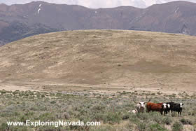
- Camping - For much of the drives length, the road passes through BLM lands. Thus, there is no shortage of camping spots. There is also a small semi-developed picnic area/camping area in the Desatoya Mountains near Carroll Summit.
Map of the Desatoya Mountains & Nearby Scenic Drives
 |
Suggested Books
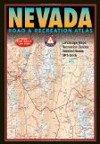 |
Benchmark Nevada Road & Recreation Atlas : This topographic map book shows ALL roads in Nevada. This book is a mandatory requirement if you'll be venturing off the main highways shown on the tourist map. Additionally, this book shows many historical sites, points of interest and recreation areas.
More Info at Amazon
|
|
Where to Stay When Driving the Desatoya Mountains Scenic Drive
Bring your tent or camper, as there is no lodging or services of any kind on this scenic drive. However, the town of Austin - which is just a few miles from the eastern start point of the Desatoya Mountains Scenic Drive - does have a few small motels. |
Related Articles & Information on Exploring Nevada
|
Copyright © 2007 - 2026 Exploring Nevada.Com
|
|
|